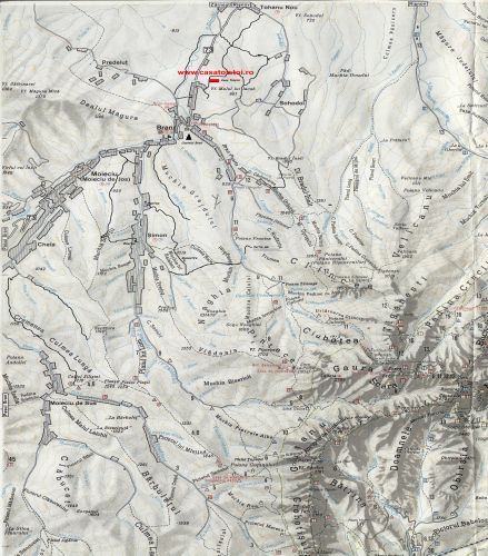
Bran Moeciu Map
Here is a map of Bran area.
We hope it will be useful.
Touristic routings:
- BRAN - CLINCEA GLADE- TIGANESTI LAP - OMU LODGE (red strip marking) 5 - 6 hours
- BRAN - CIUBOTEI GLADE - SCARA PEAK (2422 meters) - OMU LODGE (yellow triangle marking) 6 - 7 hours
- BRAN - GAURA VALLEY - OMU LODGE (red cross marking) 6 - 7 hours
- PARAUL RECE (COLD CREEK) - CHEILE RASNOVULUI ( RASNOVULUI GORGES) (yellow triangle marking) 3 hours
- PARAUL RECE (COLD CREEK) - DEALUL CU MESTEACAN ( BIRCH HILL) ( blue cross marking ) 3 hours
- POIANA BRASOV - POIANA CRISTIAN - RASNOV ( blue strip marking) 3 - 4 hours, with dirrections to:- Poiana Cristian and Cheia Lodge
- POIANA BRASOV - CHEIA LODGE ( red point marking) 3 - 4 hours
- MOECIU DE SUS - GUTANU GLADE - BATRANA LAP - PESTERA HOTEL (red triangle marking) 7 - 8 hours
- MOECIU DE SUS - PRAVALELE VALLEY - STRUNGA LAP- PADINA LODGE (red cross marking) 6 - 7 hours
Other touristic objectives
Rasnov Citadel - In the upper side of Barsa land, about 15 kilometers...
Read moreDambovicioara Cave - Located in the South side of Piatra Craiului Mountain...
Read moreBike routings and Bran hikings - Location: North-West side of Bucegi Massif...
Read moreBran Moeciu Map - Here is a map of Bran area.We hope it will be useful...
Read moreZanoaga Ski Resort - For the ones passionate about winter sports, at a distance...
Read moreBucegi Natural Park - Bucegi Massif, having a surface of approximately 300 square kilometers,...
Read morePiatra Craiului Natural Park - In the West and North-West of Rucar-Bran Corridor you can see...
Read moreTampa Natural Reservation - Tampa is located at approximate 400 meters above Brasov City...
Read moreDelta between the mountains - The Dumbravita Bran complex is the most important ...
Read more


